Where We Work
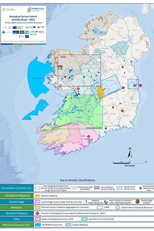
Each year Geological Survey Ireland publish a map, to highlight where our programmes will be carrying out work, called the Activity Map. This shows all of the activities planned to take place during the year for all of our programmes. It shows the specific areas, both onshore and offshore, in which surveying, research, and reporting are due to take place. Click on the link below to download the 2025 Map in PDF format:
DOWNLOAD THE 2025 ACTIVITY MAP
The relevant programmes pages (Programme name-Project name) are listed below for further information about specific projects or mapping areas of interest.
| Programme | Project (redirect to dedicated page) |
|---|---|
| Groundwater & Geothermal | GeoERA projects |
| Groundwater & Geothermal | Catchment Care |
| Groundwater & Geothermal | Groundwater Monitoring Sites |
| Geological Mapping | Bedrock Mapping |
| Geological Mapping | Quaternary Mapping |
| Geological Mapping | Landslide Project with NPWS |
| Geoheritage | County Audits (Limerick & Cork) |
| Geoheritage | UNESCO Global Geoparks |
| Geoheritage | Joyce Country and Western Lakes Geopark |
| Minerals | Minerals Prospectivity Mapping |
| Minerals | Historic Mine Sites (Mintell4EU) |
| Tellus | Airborne Geophysical Survey (A8 and A9) |
| Tellus | Ground Geochemistry Survey (G7, G8, G9) |
| Marine and Coastal Unit | INFOMAR Survey Areas |
| Marine and Coastal Unit | CHERISH Project Areas |