Dye tracing was conducted during 2015 and 2016 in the Rathcroghan Uplands to assist protection of groundwater supplies.
The Rathcroghan Uplands is a karst limestone plateau, approximately 200 km2 and 60–150 m above sea level. The Uplands generally receive 800 mm of rainfall per year and is characterised by sinking streams, swallow holes, turloughs, a relative absence of surface water courses and relatively large springs dotted around its lower-lying perimeter. These springs supply drinking water to Public and Group Water Schemes. Contamination of these springs is relatively common, and severe pollution incidents have occurred.
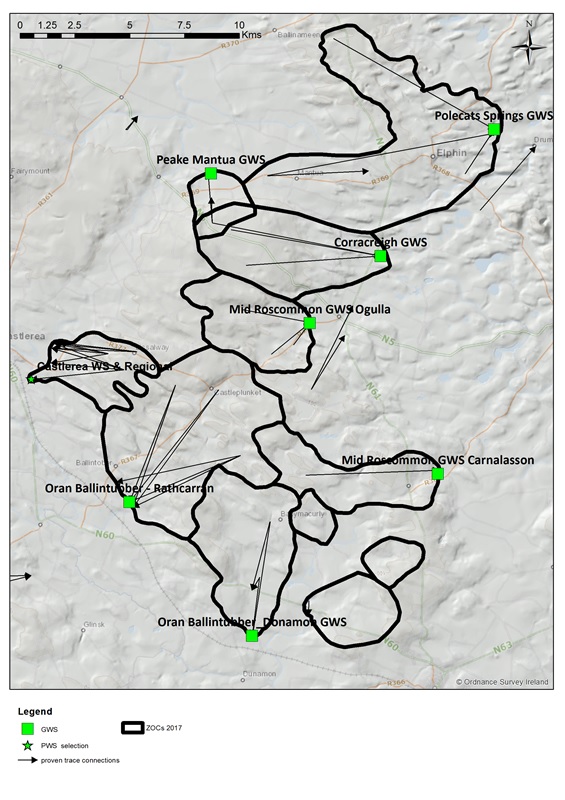
In order to protect the quality of the supplies it is important to establish the surface and subsurface catchment areas, or 'Zones of Contribution' (ZOC), within in which rainfall and potential contaminants may enter groundwater and move towards the source. These ZOCs provide an area in which to focus further investigation and implement protective measures to manage the groundwater quality and sustainable abstraction rates. Establishing ZOCs to these water supply springs has recently been carried out by Geological Survey Ireland.
Given the unpredictable nature of karst groundwater, particularly the direction of groundwater flow, establishing ZOCs requires specific techniques, significant resources, suitable antecedent weather conditions, and time. Dye tracing is one of the most important tools available to determine flow directions in such terrain. Multi-dye tracing investigations were carried out in 2015 and 2016 on and around the Rathcroghan Uplands. These traces build on previous traces in the early 2000's by the Geological Survey. The results, which are of national significance, highlighted an intricate network of flow with some unexpected directions, and provided evidence for delineating a 'jigsaw puzzle' of abutting ZOCs across the entire Uplands.
This work has significantly advanced the conceptual understanding of the karst hydrogeology of the Rathcroghan Uplands and enabled geo-scientifically robust ZOCs to be defined for all of the water supply springs. The challenging pattern of ZOCs now requires the individuals who drink the water and farm the Uplands to manage the land as a single community.

The results of the tracing and the delineated ZOCs are available on the Groundwater Data & Maps dedicated page.