Introduction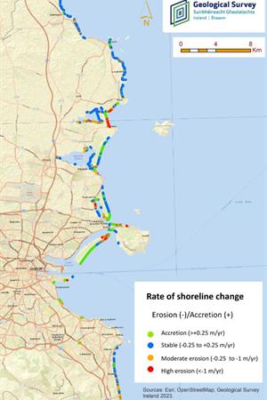
Changes to shorelines over time are inevitable due to the dynamic and complex nature of coastal environments. However, climate change driven factors such as sea-level rise and more frequent extreme storms will greatly increase the rate and scale at which coastal erosion is occurring. Coupled with the societal pressures placed on the coast, this is set to have significant impacts on coastal communities. In order for the risk of coastal erosion to be effectively managed and for coastal communities and infrastructure to be protected it is necessary for baseline information on shoreline change to be collected.
Up until now this baseline information has not been available at this level of detail on a national scale. Geological Survey Ireland is carrying out the National Assessment of Shoreline Change to provide this data to the public in a free and accessible way. This assessment focuses on shoreline change and erosion rates along soft coasts, documenting change for the period from 2000-2021. Products from this initiative can support coastal management and the refinement of climate adaptation plans, enhancing understanding of the potential physical impacts of storms, climate change driven effects and sea-level rise upon coastal systems.
Methods
For this assessment the coastline was defined as the extent of vegetation on land. A time series of imagery was used to identify the historical positions of the vegetation line and so observe historical changes in the position of the coastline. The time series used in this assessment included aerial photography and satellite imagery datasets dating from 2000 to 2021. By combining this aerial imagery with geological information it was possible to separate soft coasts from hard coasts for the purpose of this assessment. After this, the process involved; manually digitising vegetation line, quantifying of shoreline change and; assigning shoreline change classes based on the rates of change. Shoreline change rates were separated into the classes as follows:
Table 1: Shoreline change rates intervals (erosion (-)/accretion (+)).


Outputs
The National Assessment of Shoreline Change results and reports can be accessed below. It is intended that shoreline change will be maintained, updated and reissued by Geological Survey Ireland as new input data becomes available. This initiative is ongoing and counties will be updated once assessments have been completed.
Please view our Data & Maps page for data access and download.
Co. Dublin Shoreline Change