CHERISH Overview
The CHERISH project (Climate, Heritage and Environments of Reefs, Islands and Headlands) – 'Climate Change and Coastal Heritage' – is a €5.2 million five year project funded by the European Union's Ireland Wales 2014-2020 European Territorial Co-operation (ETC) programme. The project supports specialist organisations in Ireland and Wales to employ cutting-edge technologies to analyse coastal and island archaeology and heritage sites most affected by climate change, coastal erosion, storminess and rising sea levels.
The four main aims of CHERISH are to:
- Target data and knowledge gaps to raise awareness of heritage in remote coastal locations
- Discover, assess, map and monitor heritage on land and beneath the sea and establish new baseline data and recording standards
- Link land and sea
- Reconstruct past environments and weather history
The Geological Survey Ireland together with the Discovery Programme: Centre for Archaeology and Innovation Ireland (Heritage Council) are collaborating on CHERISH with The Royal Commission on the Ancient and Historical Monuments of Wales (Project Lead) and Aberystwyth University: Department of Geography and Earth Sciences as well as with communities in counties Dublin, Wexford, Waterford and Kerry to widely disseminate the results and best practice for future climate change adaptation.
CHERISH Initiatives
- Development of best practice guidance through integrated joint-nation teams employed to survey and record coastal heritage sites threatened by climate change using the latest innovative technologies and remote sensing techniques
- Establishment of permanent network of "local change" fixed survey markers and indicator wrecks
- Enhancing and updating national historic environment dataset, helping to inform priority lists for statutory designation of reefs, island and headlands
- Development of enhanced palaeoenvironmental data inventory within robust chronological framework
- Production of innovative digital "real maps" derived from LiDAR, photogrammetry and multibeam bathymetry
- Training of the citizen science to survey and record heritage at risk, climate change and storminess impacts through engaging workshops, seminars and outreach events
- Community excavations on heritage assets at risk to climate change
- Establishment of open access shared website
- Compilation of landowner management plans for climate adaptation planning
CHERISH Methodologies
CHERISH uses an integrated survey approach that combines satellite, aerial, terrestrial and marine surveys with archival and palaeoenvironmental research to complete its initiatives.
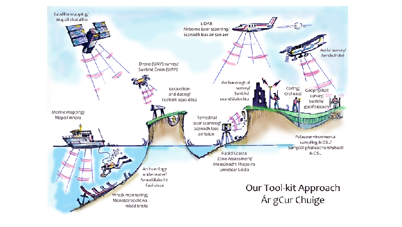 Figure 1: CHERISH integrated tool-kit approach
Case Study - Rosslare, Co. Wexford
How CHERISH is quantifying coastal change:
Coasts are extremely dynamic environments at the interface between terrestrial and marine realms. Climate change will significantly alter the ways coasts respond to erosion and sedimentation through rising sea-levels, and altered storminess and wave height. To understand the changes that are occurring now and to help predict future changes, it is critical to quantify the amount of change that is occurring around our coasts.
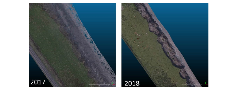 Figure 2: Sub-section of coast along Rosslare Strand surveyed in 2017 & 2018
The Geological Survey Ireland, through the CHERISH project, is surveying sections of the Irish coastline using unmanned aerial vehicles (UAV's). In Rosslare, using the optical camera on our fixed-wing Trimble UX5, we surveyed a section of the eroding sand-dunes in 2017 and returned again in 2018 (Figure 2). From these, point clouds of the shoreline were produced via photogrammetry and these were compared using CloudCompare (an open-source software) to quantify the change that has occurred (Figure 3).
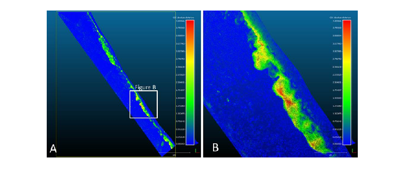 Figure 3: Elevation difference between 2017 and 2018 point clouds (0-4m)
At Rosslare we see up to 4m change in elevation with nearly 5800 m3 of material eroded as the shoreline retreats. This is not uniform, with erosion focussed at discrete regions on the shoreline (Figure 3b). Interestingly, we also see nearly 5300 m3 of sediment deposited within the studied area, meaning that while erosion is occurring, much of that material is not moving far. In total, only 500 m3 of sediment transported out of the studied region, perhaps just offshore.
This type of data is essential for informed decision making in the area and can be used today for management of infrastructure, land-use and planning, and for future climate-change adaptation and mitigation.
Technological innovation and climate adaptation
Climate change introduces new challenges to how coasts are managed. Changing coastal processes will impact sedimentation, altering ongoing erosion and accretion. The Geological Survey has been applying state of the art methodologies to investigate change in these important environments. The project supports specialist organisations in Ireland and Wales to employ cutting-edge technologies to analyse coastal and island archaeology and heritage sites most affected by climate change, coastal erosion, storminess and rising sea levels.
For Innovation week (18-23 October 2020), the Geological Survey Ireland's contribution to the innovative CHERISH project was explored in a new video.
For further information see www.cherishproject.eu/en