Tsunami Hazard and Response

  • Historical records and geological evidence indicate that, while unlikely, the Irish coast is vulnerable to tsunamis from distant earthquakes and submarine landslides.  The Lisbon earthquakes of 1755 and 1761 caused tsunamis that reached Ireland (view report).  Submarine landslides mapped by Infomar on the Rockall Bank probably caused tsunamis although coastal effects have not been recognised.  Likely worst case tsunamis around Ireland would be similar to the level of coastal flooding seen during storm surges, but with greater momentum and less time to react. 


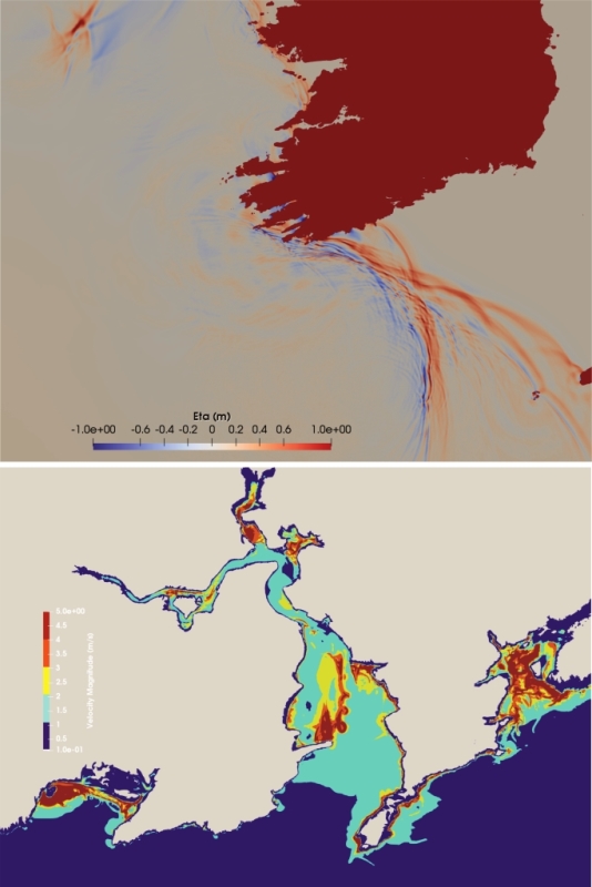
    Top: Simulated wave heights of Lisbon tsunami after 4.5 hours

    Bottom: Velocity magnitude of Lisbon tsunami wave the Waterford Harbour area


  • GSI has partnered in tsunami modelling studies for the Irish coast.  Most recently, GSI funded a study by Prof. Frederic Dias and Daniel Giles (UCD) of tsunami inundation modelling for a Lisbon 1755 earthquake scenario for two pilot areas of the coast; Galway Bay, and Waterford to south Wexford.  Results for the Irish coastline indicate tsunami travel times of c. 4 h, maximum inundation (flood) heights of c. 2 m and maximum run-up of c. 3.4 m in both pilot study areas (view report).  These results are included in a paper at this link.


  • Tsunami is included in the National Major Emergency Management guidelines, with the Department of Communications, Climate Action & Environment as the Lead Government Department.  Tsunami was added to the National Risk Matrix in 2017.


  • Geological Survey Ireland is the National Contact Point for the UNESCO/IOC Tsunami Early Warning and Mitigation System for the Northeastern Atlantic, the Mediterranean and Connected Seas (NEAMTWS).  Ireland hosted the 2015 meeting of the Intergovernmental Coordination Group of NEAMTWS.  B. McConnell is currently a Steering Committee member.  An international tsunami simulation exercise is planned for 2021 to engage with members of the emergency management and civil protection authorities.


  • Although Ireland has yet to establish a 24/7 national warning centre, we receive tsunami messages from the French (CENALT) and Portuguese (IPMA) warning centres, which are accredited Tsunami Service Providers of NEAMTWS, via the Global Telecommunications System through Met Eireann.


  • National partners include DIAS on seismic detection and Met Eireann on tsunami messaging; various bodies run sea level detection instruments, yet to be coordinated into a national system; OPW for coastal flood modelling.  GSI installed a tsunami sea level gauge on behalf of the EU JRC on Inishmore in 2019. The DIAS iMARL project includes sea-floor seismometers and a tsunami pressure gauge, funded by SFI and supported by GSI.