Activities

Activities

​​ 

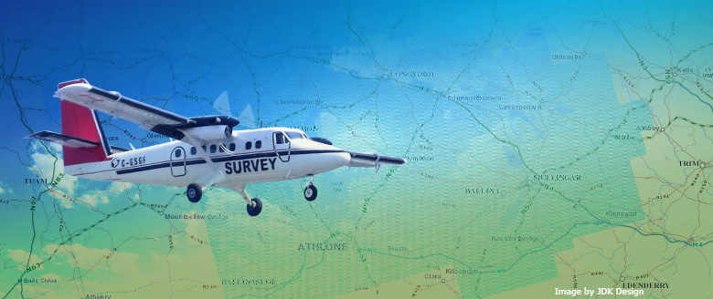
​​​Tellus involves two types of surveying – airborne geophysical surveying using a low-flying aircraft and ground-based geochemical surveying of soil, stream water and stream sediment.

Tellus is using harmonised, systematic surveying techniques across entire regions of the island of Ireland, producing seamless maps for a variety of end-users.

The coupling of airborne geophysics and ground-based geochemistry provides a richness of data which puts Ireland amongst the top countries in the world for the quality, breadth and availability of geoscience information.

Ground Survey

​Geochemical surveying characterises the baseline chemistry of soil, stream water and stream sediment by taking samples of these materials by hand at a density of approximately one sample every 4 km².

Multi-element laboratory analyses of these samples to trace-level allows a suite of some 55 maps to be produced. These are useful for mineral exploration, agricultural productivity and environmental management.

Airborne Survey

​Tellus employs a low-flying aircraft to collect geophysical information on the properties of soils, rocks and waters below ground. Flying at 60 m, the aircraft is able to sense geological properties not apparent from conventional mapping techniques, effectively ‘seeing through’ Ireland’s often deep glacial deposits and extensive peat and soil cover.

This method of acquisition is the most rapid and cost-effective means of acquiring regional-scale geophysical data for supporting geological mapping, mineral exploration, radon risk mapping and geothermal energy exploration.

Education

​Tellus produces a wealth of data on our environment and natural resources. So far 50% of the country has been mapped using thousands of geochemical samples and millions of geophysical measurements. This world-class database provides an ideal resource for teaching at primary, secondary and third levels. Tellus will work with educators to develop appropriate teaching materials at every level through existing and new education initiatives.​

Tellus County Maps

​Downloadable geophysics maps of different counties of Ireland

Applications of Tellus data

​Look how Tellus data is being used through different research projects.

Guidelines and Factsheets


Tellus produces a range of factsheets to better understand the data collected.