Geological Survey Ireland is excited to announce the upcoming release of Tellus County Maps, a series of high-quality maps each focusing on a specific county of Ireland. The first of these maps will spotlight the beautiful County Sligo.
Tellus County Maps are created using geophysical data, collected by low-flying aircraft at a height of 60m, to detect the properties of soil, rocks, and water, beneath the ground. This method allows us to uncover geological properties concealed by Ireland’s deep glacial deposits, extensive peat and soil cover, providing a cost-effective means to gather regional-scale data for geological mapping, mineral exploration, radon risk mapping, and geothermal energy exploration.
Each month, Tellus will release maps displaying magnetic, electromagnetic, and radiometric data for the different counties of Ireland. Magnetic maps are useful for exploring deep geological features, while electromagnetic maps show the boundaries between different soils and rocks, and radiometric maps provide an excellent view of the extent of peatland. The downloadable maps also incorporate a satellite base map featuring elevation data and hill shading as well as some geophysical facts about the county.
All data from Tellus is readily available online at no cost on our
website. We encourage you to keep an eye on our updates and follow us on our
social media channels to see if your county will be featured next!
Tellus is a programme of Geological Survey Ireland and is funded by the Department of the Environment, Climate and Communications.
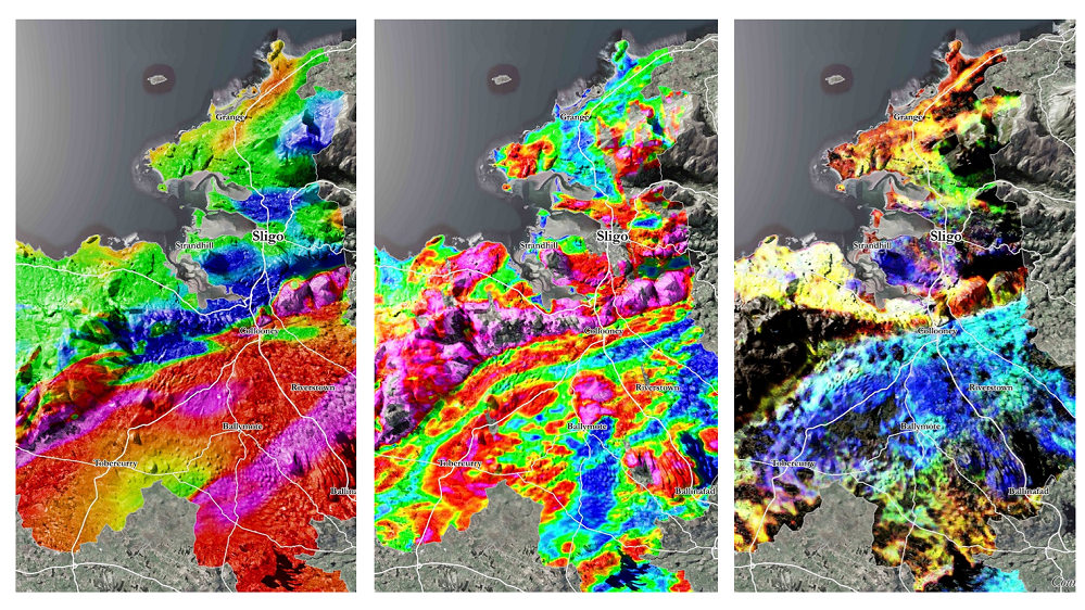 Left to right: Magnetic, Electromagnetic, and Radiometric maps of County Sligo.