1.
Karst
 |
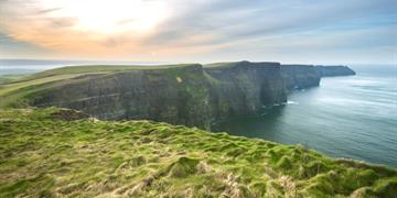
Karst is the name given to areas of limestone bedrock which have a high degree of weathering caused by solution together with a characteristic underground drainage system. Karst in Ireland is an important element of the landscape since Carboniferous limestone bedrock occurs over about half of the country, although not all of this is well exposed. Many of the well- known scenic areas are primarily of limestone terrain and are characterised by karstic landforms. The IGH 1 Karst theme aims to identify, document and select the best of these distinctive landscapes and typical features for ultimate designation as Natural Heritage Areas, in order to best conserve a network of representative sites covering the totality of karstic features present in Ireland. Karst is also a protected landscape (Natura 2000 site) under the EU Habitats Directive.
|
2.
Precambrian to Devonian Palaeontology
  | These sites cover a significant range of palaeontological interest and importance.
No genuine Precambrian fossils are yet known from Ireland, and only a small number of sites are known with Cambrian fossils. These include Bray Head with its distinctive Oldhamia trace fossil, and the Rocky Valley where microfossils have been used to correlate with other countries and define a precise age. Many of the sites are Ordovician in age, when a major radiation of fossil groups occurred and the variety of environments to occupy was greater. Shallow seas around volcanoes provided suitable conditions for many different phyla of animals, often strongly biogeographically different from those of other plates at the time. These differences in faunas help us understand the major story of Ireland's two halves.
Silurian seas were also rich in fauna. Shallow seas had rich benthic faunas of corals, brachiopods, trilobites and molluscs, such as in South Mayo. Changing faunas here show a transgression or spreading of the sea over land, as deeper water communities replace shallower ones up through the succession. In deeper water areas such as Balbriggan, planktonic graptolites dominated the ocean. At one locality, Borrisnoe, in County Tipperary, graptolites help date the oldest known land plants in the world - a site of great significance. The Devonian world was very different with a large supercontinent Gondwanaland, being quite arid and having fewer environments in which fossils could be preserved. Apart from Kiltorcan fossils, most localities have plant fossils, as the land surface had become well vegetated by this time. Many of these plants produced spores which can be invaluable for dating and correlating otherwise unfossiliferous sequences, through Munster and other areas of Ireland. |
3.
Carboniferous to Pliocene Palaeontology
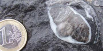 |
Nearly half of Ireland is underlain with Carboniferous strata, and much of this contains fossils of some type. It would be unrealistic to document them all; therefore a selection of sites that contain either the finest examples, unique examples, exceptional preservation, or assemblages of evolutionary or palaeoecological interest was selected for this theme.
Conversely, there are rather few sites of interest in the post- Carboniferous of the Republic of Ireland, due to erosion and removal of this younger cover of strata. The best exposures of Mesozoic and Cenozoic rocks are confined to the north-eastern part of the island, in Northern Ireland. Although it is now known that examples of such rocks do widely occur as infills in karstic features in Carboniferous limestones, knowledge of fossils is based on a small number of exposures and drill cores taken from isolated localities.
|
4.
Cambrian to Silurian
 |
These periods saw the joining together of the two parts of Ireland with the closure of the Iapetus Ocean. The Iapetus Suture Zone runs from Clogherhead in Co. Louth to the mouth of the Shannon between Clare and Limerick. Everything north of this has a geological relationship with Norway, Greenland and much of North America and everything south of the suture is closer in origin to Africa and Australia. The closure of the ocean deformed the margins of the two colliding continents and formed the Caledonian mountains.
|
5. Precambrian
 |
The Precambrian Eon covers the time from the formation of the Earth 4.6 billion years ago to 541 million years ago. In Ireland, the main suite of rocks from this time is known as the Dalradian, found in Donegal, Sligo, Mayo, Connemara, Co. Galway, and also in Tyrone and Antrim, but there are a few other examples of non-Dalradian Precambrian rocks eg. Wexford. The Dalradian is a sequence of marine sediments deposited on the rifting margin of the Iapetus Ocean and later deformed at the closing of the ocean. The oldest rocks in Ireland are the Annagh Gneiss in Belmullet ar 1.75 billion years old and Inishtrahall off Donegal at 1.78 billion years.
|
6.
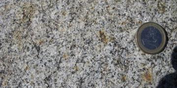
Mineralogy
 |
Minerals are individual combinations of elements that are found as distinct forms in their own right. Several thousand individual minerals are known. Igneous rocks and metamorphic rocks are usually formed from particular associations of minerals and their classification can be based on the mineral species, of which they are made, as well as texture, bulk chemistry and other characteristics such as their mode of origin.
Minerals are therefore an important geological theme to be assessed in the Irish Geological Heritage Programme. It is necessary to protect sites with occurrences of rare minerals, or where mineral species were first identified and described from. We should identify a selection of sites that represent the range of minerals known in Ireland and the places with exceptional variations, since many common minerals can occur in different forms (or habits).
The beauty and rarity of some minerals can be a big attraction for collectors and while some sites can sustain collecting, others are so rare or of limited occurrence, that restrictions should be placed on collecting at these sites to retain some for everybody to see, rather than just a few.
|
7.
Quaternary
 |
The Ice Ages over the past couple of million years have had a profound effect on our landscape. Over most of the country, the geology of the bedrock is either strongly sculpted by frost shattering and ice movements or else partially obscured by a blanket of glacial deposits. This geological heritage displays great variety and a larger number of sites will be necessary to exhibit it than for any other theme except perhaps for the Carboniferous bedrock geology which underlies about half of the land surface.
Ice accumulating in mountain slopes often developed sufficient mass to flow and carry away the rocks broken up by freeze thaw action on the joints and fractures, forming corries. Lough Doon, by the Conor Pass in the Dingle Peninsula of County Kerry exemplifies most corries with a small lake in the scooped out basin, steep back walls and superb scratches and gouges ground into the rock surfaces by the abrasive load of loose rocks carried in the slow flowing ice.
Where ice flows from corries combined or where massive accumulations flowed off high ground single glaciers could excavate 'U' shaped valleys. Extensive and repeated glaciation of upland areas in Ireland left us a legacy of landforms such as pyramidal peaks, aretes, ribbon or paternoster lakes, nunataks and others, especially in areas such as McGillycuddy’s Reeks, Killarney and the Dingle Peninsula in County Kerry. Contrasts in the landscape of glaciated uplands result from the different bedrock – granite mountains in Wicklow and Donegal look quite different to the sandstone mountains of Kerry.
Once ice sheets in lowland areas, or glaciers from high ground lost their power and motion, and remained stationary or began to recede, they could deposit their entrained load of broken and ground up rock and sediment. Till or boulder clay is the unsorted mixture that often resulted and is found widely. Often looking at the rock types within it helps track the movement of ice sheets as the rock fragments can be traced back to their source. It can also have important influence on the drainage of an area.
One of the most common landforms left by ice sheets across Ireland is the drumlin. Most people are familiar with the whaleback topography of these elongated and aligned small hillocks which dominate the landscape in large areas of Cavan, Monaghan and adjoining counties. Clew Bay in Mayo has a drumlin field which has been partly drowned by sea level rise, making small islands out of the individual drumlins.
The meltwater from glaciers often flowed in tunnels within the ice sheet. The deposition of a sand and gravel load from these high energy streams bequeathed our most famous glacial landform – the esker.
These are long, winding steep sided ridges of sand and gravel, which can run for many miles. Across large parts of the Irish Midlands, they are relatively common and were important lines of dry communication and travel through the otherwise boggy ground. Although found widely in glaciated terrains, the international name comes from the Irish, ‘eiscir’ meaning a ridge separating two plains or depressed surfaces. The eskers of Ireland are also attractive easily used sources of sand and gravel, and the challenge of finding relatively intact examples for geological NHA status is not easy. |
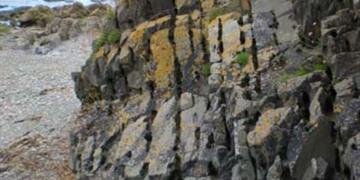
8.
Lower Carboniferous
 |
Limestone from the Lower Carboniferous is the most widespread rock in Ireland and is found in every County apart from Wicklow. Ireland was in the tropics and was mainly covered in warm shallow seas where coral reef systems developed. Much of central Ireland is underlain by fossiliferous limestone from the Lower Carboniferous. It is used as a building stone throughout the country, for example, Galway Cathedral.
|
9. Upper Carboniferous and Permian
 |
The seas of the Lower Carboniferous gave way to swamps and forests in the Upper Carboniferous. The forests are preserved as the coal seams in Arigna, Co. Roscommon and Castlecomer, Co. Kilkenny. The most famous sequence of Upper Carboniferous in Ireland is exposed on the Cliffs of Moher in Co. Clare. Here the beds of siltstone, sandstone, and shale show the evolution of the sedimentary environment from that time. The Permian saw the change in Ireland too much drier conditions and the subsequent formation of evaporites, for example, Gypsum in Kingscourt in Co. Cavan.
|
10.
Devonian
 |
Life transitioned onto land during this period. This is best illustrated by the amphibian trackways preserved in Valentia Island, Co. Kerry. The trackways are the earliest example of animals in a terrestrial environment and because of this, they are of international importance. Ireland was in the southern mid-latitudes during the Devonian and the environment was mainly desert. Large quantities of red sandstone (Old Red Sandstone) were deposited in Munster. The Caledonian granites, e.g. Wicklow and Donegal, are also Devonian in age but these are examined under IGH 11 - Igneous Intrusions.
|
11.
Igneous Intrusions
 |
There are two main types: the major bodies such as granites, and the minor features such as sills and dykes. The Wicklow Granite is an example of a major body. It was formed 400 million years ago and is actually made up of several different phases of crustal melting and intrusion of massive bodies, which now form the Dublin and Wicklow Mountains.
Various dykes, narrow sheets of igneous lave which cut across any structural or sedimentary features of pre-existing host rocks. They usually relate to periods when the Earth's crust was under tension and large scale fractures were filled by molten lava from depth. In Northern Ireland, the earliest rifting associated with the opening of the Atlantic Ocean caused major outpourings of lavas in County Antrim. Across other parts of Ireland, dykes of Palaeogene age (around 60 million years ago) are known.
|
12.
Mesozoic and Cenozoic
 |
Most of the relevant sites are thought to be karstic depressions (dolines) or caves, such as Ballygiblin in County Cork where sediments have been preserved from sustained erosion. Ballydeenlea, near Killarney in County Kerry is one of the most famous as it includes Chalk deposits (widespread over southern and eastern England) otherwise only found in Northern Ireland. Did a Chalk sea once cover Ireland? Protecting sites such as this is the only way to allow answers to be found in the future.
|
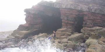
13.
Coastal Geomorphology
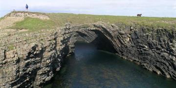 |
Coastal geomorphology is the theme that includes all the landforms around the coast of Ireland, which have been created by the power of the sea. This theme will be trying to find the best examples of particular landforms. The panel will also try to identify locations where processes are actively happening today and the development of the landforms themselves, through recent time can be studied.
Landforms can be of two categories, those formed by erosion and those formed by deposition. Of particular note amongst erosional sites will be such features as sea cliffs, sea stacks, and rock arches. Sites where deposition of sand, gravel or boulders occurs may include spits, tombolos, barriers, beaches, and bars. Finer grained deposits of mud or silt may be found in estuaries and mudflats.
Other landforms may be created by drastic changes in relative sea level. During the Ice Ages, thick sheets of ice depressed the land surface. As the ice melted the land bounced back, and created raised beaches in some localities. In other places, the sea level rose with all the ice meltwater, and drowned river valleys.
Whilst there are very many practical problems with trying to conserve many of these dynamic landforms, with all the rich heritage of our seascapes it is important to identify key sites for educational understanding and for fair treatment in any attempted coastal zone management.
|
14.
Fluvial and Lacustrian Geomorphology
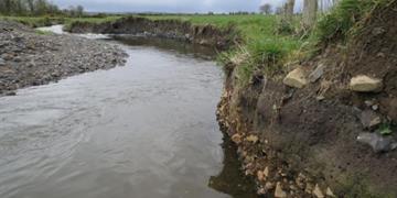 |
Environments and landforms related to rivers and lakes. They include erosional and depositional features. the relationship to groundwater systems, relationship to the underlying bedrock geology and evidence of exploiting features formed during the last glacation.
|
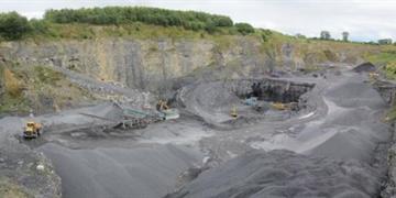
15.
Economic Geology
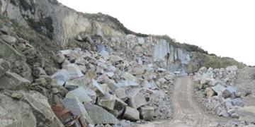 |
Geology is not just an academic study of the earth, but principally a practical subject, whereby the theoretical understanding of processes and events in the record of the rocks are translated into discovery, exploitation, and use of geological resources. This geological foundation of resources to support cultural and economic development is equally worthy of assessment for the purposes of identifying and protecting key sites of value in the spectrum of geological heritage. Metallic mine sites are perhaps the largest group but numerous non-metallic minerals, building stone, and specialised deposits are all in need of appraisal in this IGH theme.
|
16.
Hydrogeology
 |
This geological theme is a very specialised one which will eventually select only a handful of sites which are important for their exceptional characteristics. The kinds of sites to be examined include warm springs, other non-karstic springs, or sites which demonstrate particular hydrogeological processes or unusual water chemistry. Some of the warm springs known around the country have been tapped for public or private supplies or to make sure of the heat, so the number of sites will probably be quite small, but they will be worth flagging as NHAs for their unusual nature.
|