For a relatively small area, 70,000 km2 Ireland has a diverse geology. One of the most interesting aspects of the geology of Ireland is studying its origins.
Studies of plate tectonics tell us that Ireland once had a very different setting. Hundreds of millions of years ago the land that makes up Ireland as we know it today existed on two continents known as Laurentia and Gondwana that were separated by an ocean called Iapetus. The northern part of Ireland was located on the continent of Laurentia, preserved as parts of modern North American. The southern part of Ireland was located on Gondwana, now preserved as large parts of Europe, Africa and Australia.
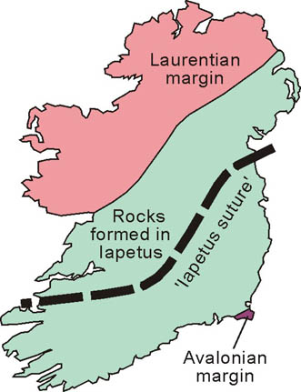
Over 470 million years
ago the ocean was closing and eventually the two continents collided, the impact of this collision can be
seen in the way mountains over much of the island display long axes that
trend north-east to south-west - a direction that reflects the line
along which the plates clashed. A scar from Dingle on the west coast to
Clogherhead on the east shows the line along which the two continents
combined.
 2.6million years ago to recent times 2.6million years ago to recent times
|  200million years ago to 165million years ago 200million years ago to 165million years ago
|
 360million years ago to 330 million years ago 360million years ago to 330 million years ago
|  450million years ago to 415million years ago 450million years ago to 415million years ago
|
The land that is now Ireland then moved north close to the equator, at this time, known as the Carboniferous period, a sea extended across Ireland allowing for the for the formation of sedimentary rocks such as sandstone and mudstone. Over the next 50 million years limestone deposits formed in the warm waters.
Other geological features of Ireland include:
● The mountains of south Munster formed by strong folding due to large amounts of pressure in the Variscan period.
● The Giant’s causeway, columns of distinctive black basalt that formed around 60 million years ago when the Atlantic re-opened and caused sea floor spreading. This separation caused increased volcanic activity and allowed lava to spread over what is now Antrim and Derry.
● Glacial features such as U-shaped valleys and corries. Global temperatures fell during the Neogene times and Arctic ice sheets spread across northern Europe. This was the beginning of the Quaternary period and over the following 1.7 million years several periods of ice advance and retreat shaped the face of Ireland, evidence of only the last two glaciations can be seen.
Bedrock map of Ireland

Irish bedrock maps shows both the onshore and offshore bedrock geology Ireland. Bedrock is the hard, solid rock beneath surface materials such as soil and gravel. Bedrock also underlies sand and other sediments on the ocean floor. Bedrock is consolidated rock, this means it is solid and tightly bound. Overlying material is often unconsolidated rock, which is made up of loose particles.
Bedrock can extend hundreds of meters below the surface of the Earth, toward the base of Earth's crust.
The bedrock map shown above is to the scale 1:1,000,000; with this scaling every 1cm of the map relates to a distance of 10km. To construct a bedrock map, geologists record the position of data points such as rock outcrops and boreholes. For each of these data point the record comprises a description of the type of rock, a measurement of inclination and other factors. This process is made more difficult in Ireland due to unconsolidated glacial deposits covering large areas. This means that data points can be few and far between and makes interpretation of data more difficult.
The bedrock map of Ireland shows a wide variety of rock types which have originated at different periods of geological time.
The oldest rocks are metamorphic and are found in areas such as Malin Head in Co. Donegal. They originally formed as igneous rocks 1750-1780 million years ago.
Other old metamorphic rocks include the slates that have given rise to the slate quarry at Valentia Island, Co. Kerry, and the quartzites that are found in Counties Donegal and Wicklow.
Extrusive Igneous rocks, igneous rocks that have formed above the earth’s surface, are common in the north-east where the basaltic lavas have given rise to the Antrim-Derry plateau. Intrusive igneous rocks, igneous rocks that formed below the earth’s surface, such as granites can be seen in Counties Donegal, Armagh, Down, Wicklow and Galway.
Sedimentary rocks are widespread. They include the Old Red Sandstones from the Devonian period. These are common in the 'ridge and valley' landscape that runs across much of south-west Ireland. Limestone also covers much of the country most notably in the midlands and in areas such as the Burren in Co. Clare.
GSI produced a book aimed at teachers and enthusiasts alike to better understand earth processes, rocks and the geology of Ireland. Please see dedicated publication page to download the book or purchase it from the online shop.
For more information about Ireland's geology, please see our Geological Mapping programme.