Geological Survey Ireland has been monitoring flood levels at Lough Funshinagh, Co Roscommon since 2016, and through recent collaborative work with the South East Technological University, a preliminary analysis has been carried out into possible future flood behaviours at the Lough.
Current Levels
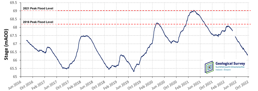
Despite a lengthy period of uninterrupted drainage since April 2022, the water level in Lough Funshinagh is still relatively high for this time of year (66.3 m above ordnance datum, or approx. 3.3 m depth). The Lough has experienced some seasonal water level increases in 2022 with levels rising between January and March by approx. 0.55 m (corresponding to a volume of approx. 3x10⁶ m3). However, the relatively dry weather conditions since April 2021 have overall led to a significant drop in level over the last 18 months. Since the record breaking April 2021 flood peak the Lough has decreased in volume by approx. 75% (12.4 x 10⁶ m3). For any year prior to 2021, this volume of water removed from the Lough would have resulted in the Lough draining completely. However, this is not the case in 2022 due to the excessive levels of reached in 2021 (69 mAOD) which the Lough has not recovered from. The flood level timeseries is presented below in Figure 1. For more information on historic flood levels at Lough Funshiangh and other sites please visit gwlevel.ie.
Potential Future Levels
The potential future flood behaviour at Lough Funshinagh has been estimated by assessing historic rainfall trends. The last 30 years of historic Met Eireann data was inputted into a hydrological model of the Lough and used to produce a statistical analysis of how flood patterns may evolve in the Lough over the next 18 months.
The results of this analysis, carried out in September 2022, are presented in Figure 2. The probabilities of different flood levels over time are presented in the form of a heatmap where dark blue pixels indicate a greater probability and pale blue pixels of lower probability. In addition to the heatmap, frequency quantiles are presented as grey lines (for the 5th, 25th, 50th, 75th and 95th quantiles). These lines indicate the proportion of model scenarios which indicate that the water levels at Lough Funshinagh will be less than or equal to a given level. For instance, for each instant of time, 50% of the model runs suggest flood level below the 50th quantile (the continuous grey line) and 50% of the model runs suggest flood level above the 50th quantile.
Preliminary results indicate:
- The estimates suggest that there is a 50 % probability that water levels in Lough Funshinagh could reach approx. 67.45 m in 2023 (1.55 m below the 2021 peak and 1.15 m above the current level).
- The estimates suggest that there is 25 % probability that levels will reach above 68 m in 2023. The probability of levels reaching or exceeding peak levels in 2023 comparable with 2021 (69 m) is less than 5%.
- The estimates suggest that there is a 25 % probability that peak levels remain below 67.1 m in 2023 and a 5% probability that peak levels remain below 66.3 m.
- The estimates suggest a 25% probability that in Autumn 2023 Lough Funshinagh will drop as low as it's lowest recorded level since 2016, 65.3 m. Furthermore, there is a 5% probability that the Lough will drop as low as 64.7 m (i.e. nearly empty).

It should be noted that work on the Lough Funshinagh model is ongoing. Results are subject to change and should be interpreted with caution.