Geological Survey Ireland host maps that can help you to determine if karst development is likely in your area. The Bedrock Geology Map of Ireland (available in 1:100,000 scale) will show you if you live in a limestone area. Karst can form on any rock that is soluble in water. This can be gypsum and other evaporate rock, but it Ireland most karst is found in Carboniferous Limestones. (See our Groundwater online viewer, with the Bedrock 100k layer to explore the Carboniferous limestone).

Map Karst landforms, mostly caves, developed at the boundary between limestone and shales and sandstones, the Burren, County Clare.
Karst Databases
Geological Survey Ireland has two main databases that are specific to karst; The National Karst Landform database and the National Water Tracing database. Both databases are inventories of all known landforms and water trace experiments and contain details and attributes specific to each entry. The sinking streams dataset is also a useful database from a water quality point of view. It records surface water features that eventually sink into the karst bedrock. In some cases, the sinking streams may not be located on karst rock, at least upstream of where they sink underground, and can be a considerable distance away from karst rock.
The karst landform database
An All-Ireland karst Landform database is now available, covering both the Republic of Ireland and Northern Ireland. It is an inventory of all known karst landforms and was first developed in 1999 by Morgan Burke and the Geological Survey, Ireland. The primary purpose of the database was to compile and store details of known karst features. Data were initially complied from a variety of sources including maps, literature, company records, borehole records, quarry operators and field mapping. The database is continuously updated as new information becomes available, usually from fieldwork or remote sensing techniques.
Information is recorded in the database for a variety of karst landform types: caves, enclosed depressions, dry valleys, turloughs, swallow holes, karst springs, estevelles, limestone pavements and karst found in boreholes. General details relevant to all these landform types, such as locational details, are recorded. Each landform type also has a specific set of fields, depending on the attributes of the landform. For example, for caves information on passage dimensions and length are recorded and for karst springs information such as mean discharge and variation is recorded.
Each feature can be queried by type, location or its individual attributes. The database is usually displayed according to each feature's landform type:
The database currently contains details of over 12,100 landforms (11,300 in the Republic of Ireland and 820 in Northern Ireland). However, to database is not comprehensive as not all areas have been mapped to the same level or indeed mapped at all. The map below shows the current output of the Republic of Ireland, showing significant data gaps.
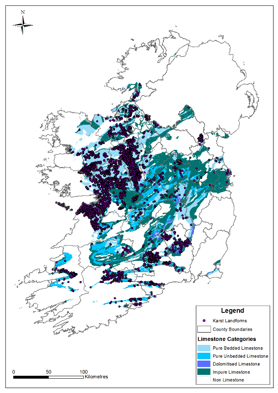 Map The current output from the National karst database and karst limestone types (note the database is incomplete).
To report a karst feature, please email the Groundwater section at groundwaterinfo@gsi.ie
The water tracing database
Water tracing entails 'tagging' water, usually by use of a soluble dye, to monitor where it goes. The Geological Survey's water tracing database was created in 2007 to compile and detail water tracing experiments carried out in Ireland. It is an inventory of all known water trace experiments and stores details for each trace. Data are compiled from numerous sources such as academic and caving journals, company reports and personal communication.
There are twenty fields, which can be queried by topic, location or catchment. These fields are summarised in the table below. Positive traces are recorded as a straight line, input-outflow, and are not necessarily representative of the actual path water may take. The water tracing database is designed to complement the karst database. It has recently been also been extended to include Northern Ireland and contains information on over 530 water traces (465 from the Republic of Ireland and 69 from Northern Ireland, with some traces crossing the border).
| Input Site | Records the type of input (e.g. swallow hole, sinking stream, turlough) and feature name (if any) |
| Input Number | Corresponds to the karst feature number from the GSI's karst feature database |
| Output Site | Records the type of output site (e.g. spring, river) and the feature name (if any) |
| Output Number | Corresponds to the karst feature number from the GSI's karst feature database |
| County | Records which county/ counties the trace occurred in |
| Surface Water Catchment | Records which surface water catchment(s) the trace occurred in |
| Date | Records the date which the water trace took place |
| Weather Conditions | Details the weather conditions at the time of trace. For example, high flow conditions, low flow conditions |
| Tracer Used | Records the type of tracer used. For example optical brightener |
| Quantity | Records the quantity of tracer used |
| Operator | Records who carried out the trace |
| Result | Degree of certainty (e.g. weakly positive, dubious result) |
| Flow Rate | Minimum flow rate to peak of tracer breakthrough (m/hr) |
| Hydrological Gradient | Hydrological gradient from input to output |
| Peak Concentration | Records the maximum tracer concentration observed at the sampling point |
| True Representation | Records whether trace is considered to be linear (i.e. A goes to B) or via a more complicated route (i.e. A goes to B via C & D) |
| Data Source | Records the data source of trace |
| Additional Information | Additional comments about trace, inputs and outputs etc. |
| Flow Path | Describes the suspected flow path (if known) |
Table List and explanation of the fields in the groundwater tracer database
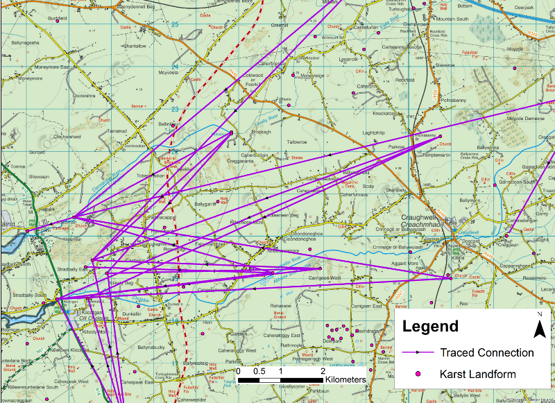 Map An example of GSI karst water tracing database
Both databases are available as a downloadable layer for use in GIS or can be viewed and queried on the GSI's groundwater online viewer.
Sinking streams database
The sinking streams database was created as part of the Groundwater Vulnerability Map. It is one of the primary layers that feed into the overall Groundwater Vulnerability Classification. For more on GSI Groundwater Vulnerability click here. Karst is an important consideration of groundwater vulnerability; recharge through karst features such as swallow holes and sinking streams is taken into account in the vulnerability mapping as areas around these are classified as 'extremely' vulnerable to groundwater pollution. Groundwater is classed as 'extremely' vulnerable within 30 m of certain karst features, including along the area of loss of losing or sinking streams, and within 10 m on either side of losing streams upstream of the area of loss. The distances can be varied depending on the circumstances - for instance, they can be increased where overland surface runoff is likely.
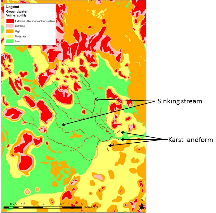 Map An example of the GSI Groundwater Vulnerability map, showing extreme vulnerability around karst landforms and sinking streams
Turlough Monitoring Data Sheets
The turlough monitoring station data sheets present information on data collected at Geological Survey Ireland monitoring stations. The monitoring stations are mostly located on seasonal lakes known as turloughs, and these data sheets provide information regarding their location and monitoring period as well as summary plots of stage, volume, flood area and net flow. The datasheets are available to view and download here.
 Image An example of a GSI Monitoring Station Data Sheet
Other Geological Survey Ireland maps and datasets relevant to karst
Groundwater is protected in Ireland by means of Groundwater Protection Schemes, which are groundwater protection zones, produced by the combination of aquifer classification and the natural vulnerability of the groundwater to pollution. Karst is an important consideration of these schemes; recharge through karst features such as swallow holes and sinking streams is taken into account in the vulnerability mapping, and giving an 'extreme' vulnerability classification, as described above.
The aquifer map distinguishes between limestones with and without a high degree of karstification. In the delineation of source protection zones, two source protection areas (SPAs) are delineated around each public supply well and spring: an Inner Protection Area (SI), defined by a 100-day travel time within the aquifer from any point below the water table to the source, and an Outer Protection Area (SO), encompassing the source catchment area or zone of contribution (ZOC). Karstification is taken into account in these SPAs, firstly because the area in the immediate vicinity of karst features that enable water and pollutants to bypass the subsoil are classed as 'extremely' vulnerable areas and secondly, all the area of karst limestone in the ZOC is generally classed as an inner protection area (SI), as travel times to karst sources are generally rapid.
In the groundwater protection responses, the greatest degree of restriction is on developments on extremely vulnerable, regionally important karst aquifers. Groundwater Protection Scheme reports, Source Protection Scheme reports, Zone of Contribution Reports and other useful reports are freely available on Geological Survey Ireland's website.
These datasets are available for viewing on our interactive public viewer or for downloading. Please visit the dedicated Data & Maps page for Groundwater.