Geological Survey Ireland offers a number of small grants each year to support the sustainable development, promotion and recognition of Ireland's geoheritage. These grants are aimed at local community-driven outreach and development initiatives with a geoheritage theme. The grants are made through an open competitive application process.
In the 2022/23 round of grant funding, Geological Survey Ireland has awarded Geoheritage grants to six community-based projects around the country. These grants will support the development and publication of educational and outreach materials by local groups, established geotourism sites, aspiring geoparks and UNESCO Global Geoparks. The aim of the fund is to encourage the telling of the Irish geological story, improve the understanding of geoscience, and to engage with groups throughout the country.
|
|
|---|
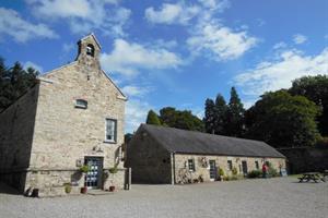 | Castlecomer Discovery Park
Castlecomer Discovery Park is an organization based in Co Kilkenny and will produce an online-linked geology trail to showcase the geoheritage of the Castlecomber Discovery Park and the unique geology of the Castlecomer area. The geoheritage highlights include Castlecomer’s coal mining heritage and the discovery of rare Carboniferous amphibian fossils in 1864. A geological map of the Castlecomer area will be created, which will also be present on the physical paper trail guides and will be provided to schools taking the new Geology session. The trail aims to promote the geoheritage to schools and the public both within the local area, and the larger catchment of Castlecomer Discovery Park (including Kilkenny, Carlow, Wexford, Waterford & Dublin). |
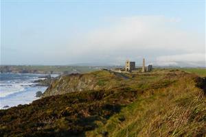
| Copper Coast UNESCO Global Geopark
The geopark aims to create a new generation of geoheritage focused trails. The new trail card’s content would focus on the geoheritage and historic mining sites at areas such as Tankardstown Engine house, Ballydowane Cove and Annestown Beach which would be both printed and posted online. Each geoheritage map will contain points of interest and feature information about the geological heritage of specific areas as well as general information about the area’s geology. The maps will be suitable for users to walk or cycle through quiet roads and off-road sections to discover outcrops and other sites of geological interest as they go along. |
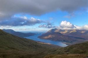 |
Joyce Country and Western Lakes Aspiring Geopark
The aspiring geopark aim is to highlight and showcase the karst landscape of the Joyce Country and Western Lakes geopark region in Counties Mayo and Galway by producing an animated video which endeavours to tell the story of the karst landscape development that takes place over centuries to millennia. The video will focus on the karst landscape of the western lakes (Loughs Carra, Mask and Corrib) that has developed in the lower Carboniferous limestone and the unique karstic features to be found there including the Cong Isthmus area with the Cong Canal development, the Lough Mask shore epikarst feature and the Lough Carra marl lake processes.
|
 | Bioregional Weaving Lab Waterford
The proposed project is to explore and then generate a digital map that captures the essence of both the heritage of the landscape and the communities living in the area of the Copper Coast and surrounding areas of Co Waterford. |

| St Johns Old Cemetery Restoration Group
This small community-based group are currently developing a restored eighteenth-century church into a visitor attraction known as Nobber Heritage Centre. The group aim to tell the area’s geological story using locally sourced rock and fossil specimens which will be housed in display cabinets. Display panels will detail various aspects of the local geoheritage including the Kingscourt half-Graben, Gypsum Mines, karst and drumlin belt Quaternary landscape. The display will also have an audio-visual component by using drone-captured video of the landscape and some of the more important geological sites and exposures. |
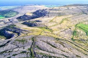 | Burren & Cliffs of Moher UNESCO Global Geopark
The proposal is to design and produce of a series of short animations that graphically tell the story of the geological history of the Burren and Cliffs of Moher UGGp. The animations aim to tell the stories of the geology of the geopark and include the formation of the Burren limestone, the sandstone and shale of the Cliffs of Moher, fossils in the Geopark, the plate tectonic journey and the Ice Age. These stories will connect the geological processes with the local landscape and promote geoheritage awareness among all age groups and to a wide-reaching audience. |
| | |