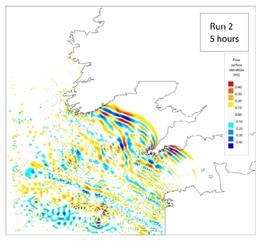
Historical records and geological evidence indicate that, while tsunamis are unlikely events around Ireland, the Irish coast is vulnerable to tsunamis from submarine landslides and distant earthquakes. Levels of coastal flooding are expected to be similar to those seen during storm surges, but with much more energetic inundation and a much shorter time to react. A mathematical simulation of the Lisbon 1755 earthquake and tsunami event [here] indicates tsunami wave heights of up to 3.5m along the south coast of Ireland. Similar modelling of past landslides mapped on the Rockall Bank suggests tsunami wave heights of a similar scale could impact the west coast. These events are the subject of on-going research. There has also been considerable publicity around the idea that a large tsunami could be generated by collapse of La Palma island, but most experts believe that volcanic collapse would be gradual and not cause a tsunami.
An international tsunami detection and alerting system, coordinated by the Intergovernmental Oceanographic Commission of UNESCO, is in place and has been tested a number of times. Ireland contributes seismic and sea level data to the system, participates in simulation exercises, and receives tsunami messages from the French Centre National d'Alerte Aux Tsunamis (CENALT). Geological Survey Ireland is working with national partners, including the Office for Emergency Planning, Met Éireann, Dublin Institute for Advanced Studies and the Office of Public Works, to enhance the monitoring system, estimate the risks and develop an appropriate emergency response plan. There is currently no system in place to convert international tsunami messages to national warnings if required, but tsunami has been recognised as a potential risk to Ireland in the draft of the revised National Risk Assessment for Ireland.
NEAMTIC tsunami information