Geological Survey Ireland has been monitoring flood
levels at Lough Funshinagh, Co Roscommon since 2016, and through a new
collaborative project with I.T. Carlow, a preliminary analysis has been carried
out into possible future flood behaviours at the Lough.
Water levels in Lough Funshinagh are currently
exceptionally high. Thus far in 2021 the turlough has reached record levels,
exceeding the previous known record in 2016 by approximately 0.8 m. The peak
level was recorded on the 3rd of April when the turlough reached 69.04m (meters
above sea level). Since then the turlough has dropped slightly, with levels of
68.75 m recorded as of the 20th of May. This data is available to
view at: https://gwlevel.ie/
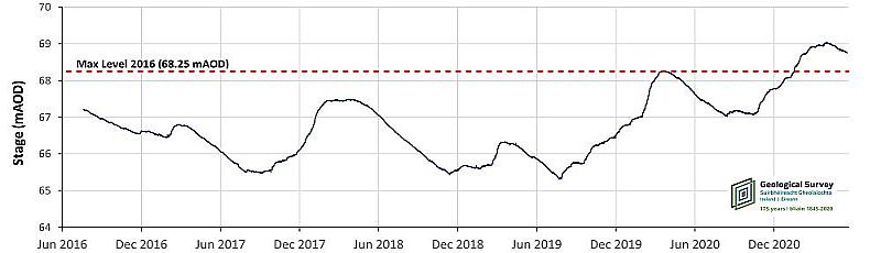
Figure1: Water level hydrograph for Lough
Funshinagh, Co. Roscommon. June 2016- May 2021 (GSI datalogger is positioned at
63.5m AOD)
The potential future flood behaviour at Lough Funshinagh
has been estimated by inputting 80 years of historic Met Éireann rainfall
timeseries into a hydrological model of Lough Funshinagh. In this manner, the
model can produce a statistical analysis of how flood patterns may evolve in Lough
Funshinagh over the next 18 months based on current water levels coupled with historic
rainfall trends.
The results of this analysis, carried out in April
2021, is presented in Figure 2. The probabilities of different flood levels
over time are presented in the form of a heat map where yellow pixels indicate
a greater probability and blue pixels of lower probability. In addition to the heatmap,
frequency quantiles are presented as green lines (for the 5th, 25th,
50th, 75th and 95th quantiles). These lines
indicate the proportion of model scenarios which indicate that Lough Funshinagh
will be less than or equal to a given level. For instance, for each instant of
time, 50% of the model runs suggest flood level below the 50th
quantile (the thickest green line) and 50% of the model runs suggest flood
level above the 50th quantile.
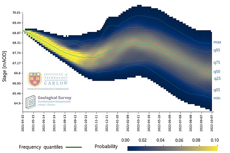
Figure
2: Probability analysis of potential future flooding scenarios in Lough
Funshinagh based on historic rainfall trends.
Preliminary results indicate that:
There is a 50% probability that water levels in Lough Funshinagh
could reach approx. 68.4 m in 2022 (65 cm below the 2021 peak, and
slightly higher than the 2016 peak).
The probability of Lough Funshinagh reaching
levels comparable with 2021 is between 5 and 25%
There is a 50% probability that water levels in
Lough Funshinagh will not drop below 67.4m during the remainder of 2021.
The
considered hydrological model can reproduce the observed flood levels at
Lough Funshinagh between 2016 and 2021, which indicates that there has not
been any relevant change in the hydrological functioning of Lough Funshinagh
in the past 5 years.
It should be noted that work on the Lough Funshinagh
model is ongoing. Results are subject to change and should be interpreted with
caution. However, though preliminary, the results have been shared with
Roscommon County Council to assist in the management of flooding at Lough
Funshinagh. For more information on our groundwater flooding monitoring and
mapping work, see here.